[vc_row][vc_column][vc_column_text]
Learning outcomes
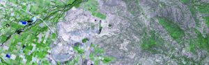
In this theme students will learn about what a GIS is, how to get started with the software, how objects in the real world can be represented on a map, how locations are recorded using coordinates, and how a two-dimensional map can be made from a three-dimensional Earth. In the theme project, students will create their own GIS data by tracing geographic features from a satellite image for a location and theme of their choice. This theme will provide a strong foundation in mapping and GIS that will give students the understanding they need to start working with GIS, and to continue to the other two themes in this course.
Course Content
- What is a GIS?
- Introduction to QGIS
- Vector and raster data (Mapping the real world)
- Coordinate Systems (Mapping Locations)
- Map Projections (Flattening the Earth)
- Project : Creating Your Own Data
Course Delivery
The course is presented through lectures in videos followed by brief quizzes. Brief instructions will be provided to guide students through the practical hands-on sessions.
Assessments
The course is assessed through exercises and project reports that must be submitted on-line.
Intended audience : Anybody who works with spatial data.
Instructors : Prof Fethi Ahmed and his team[/vc_column_text][vc_btn title=”Register now” style=”custom” custom_background=”#72d62a” custom_text=”#ffffff” size=”lg” align=”center” link=”url:http%3A%2F%2Fafricanremotesensing.org%2F%3Fpage_id%3D6599%26preview%3Dtrue|||”][/vc_column][/vc_row]